1890s Aberystwyth
This reproduced Ordnance Survey map shows accurately what Aberystwyth looked like in 1890. The foundations of the current layout are clear, but there have been many changes since! Click the map to view at full size.
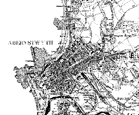
View Full-Size (146kb)
What's Different?
- Seafront: New Promenade, which curves around the western edge of the town from the pier to the harbour had not been constructed at the time of this map. Note also how much longer the pier is than today.
- South: Smithfield Road is now Park Avenue, and now leads to a 1990s road out of town. The railways have been hugely scaled back. The Carmarthen railway line, which curves away towards Trefechan is long gone, as is the goods yard.
- East: South of Llanbadarn Road, the quarry and marshland around Buarth Mawr have given way to housing, the Art School, student halls and office space. Further North, barracks have been replaced by the hospital, and the Dan-y-Coed estate on Penglais Hill has radically changed the character of Penglais Hill.
- North: Many new houses here since, with land above the town hall giving way to North Road initially, and later new estates up the hillside.
Image produced from the www.old-maps.co.uk service with permission of Landmark Information Group Ltd. and Ordnance Survey.
This page updated 17-Jul-2007